 |
| NGO RRDC show shocked community members the true extent of displacement |
After an outcry from environmentalists the Federal Ministry of Environment put a halt to the project pending an environmental impact assessment of a project which passes through much Nigeria’s last protected forests and over 180 communities. The Governor has been vocal about continuing with the project despite its controversy and the States heavy debt profile.
One year later the absurdity of the 20.4km width and the enormous loss of property and land stands unchanged. Many have no clue the road is gulping an additional 10 km on either side for a so-called “buffer zone” which aides have explained will be used to “build new cities” not reflected in any budgets.
Stories abound of unprecedented logging, documented destruction of farms and possible placement of “MOU” banana, sugar cane ethanol and other plantations owned by foreign investors on this seized land.
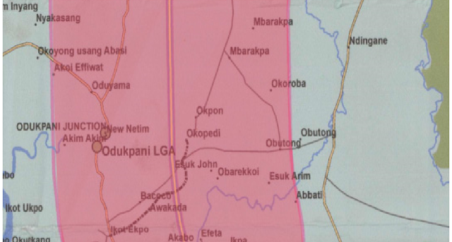
Here is a breakdown of the map starting from Bakkasi that shows in detail names of communities affected. This is clearly inconclusive but it serves as a guide. Note if your community name falls anywhere within the pink zone your land and property is no longer yours. If it is on the line then it falls within the 400 m for the actual road. You can neither sell, develop, take any loans or use it as equity for any business. It ceased to be yours 6 weeks after the land was revoked on 22nd January 2016.
Enjoy the silence and happy anniversary! Pamela Braide
Special thanks to NGOCE for providing the map. They have a huge one hanging in the office.
Section 1.
 |
| The map from which above excerpts were derived |
 |
| Map from NGO's with vegetation |
 |
| Cross River Government notice. Jan 22nd 2016 |
 |
| Cross River Government notice Jan 22nd 2016 |
 |
| List of communities affected by cross river super highway extracted from map by no means complete |
 |
| List of communities affected by cross river super highway extracted from map by no means complete
Videos
|


